🌿 National Park · Prospective Analysis · Semois Valley 2040
Semois Valley : Prospective Analysis
National Park, Forests & Ecological Transition
28,903 hectares of living laboratory. Innovative governance, forest resilience
against bark beetles, river restoration and quality ecotourism
with a 2040 horizon — an analysis based on official sources (PNVS, ISSeP, CRSC, DNF).
Audio version of the complete prospective analysis of the Semois Valley: PNVS governance, forest resilience, aquatic restoration and ecotourism directions to 2040.
Prospective analysis · Official data PNVS, ISSeP & SPW 2026
The Semois: a living laboratory for the Ardennes of tomorrow
The Semois Valley, an emblematic hydrographic entity in southern Belgium, faces ecological, climatic
and socio-economic changes of unprecedented scale. Historically valued for its forestry and agricultural
resources, this territory is undergoing a major strategic transition formalised by the
designation, in December 2022, of the Semois Valley National Park (PNVS).
This territory of 28,903 hectares, spanning the provinces of Namur and Luxembourg,
positions itself as a laboratory for climate adaptation and territorial engineering. Forest covers
86% of the territory, but is bearing the full brunt of global climate change.
"The prospective analysis of this region requires examining how the dynamics of shared governance,
forest resilience, hydromorphological restoration and territorial planning interact to redefine the
balance between strict biodiversity conservation and sustainable economic attractiveness by 2040."
— ISSeP, Presentation of the PNVS and needs of Walloon national parks, 2024
Walloon national parkForest resilienceAquatic restorationQuality ecotourismLiDAR monitoringGreen & blue infrastructure
28,903 haPNVS area across 8 municipalitiesPNVS, Dec. 2022
13 M€Walloon Government grant to prize-winning projectsPNVS Foundation
86%Forest cover of the Park territoryISSeP 2024
287 haNew Integral Forest Reserves in 2024DNF / PNVS
1,000Wild brown trout fry reintroduced (genetics programme)PNVS
Partnership architecture · PNVS Foundation · Executive committee
Territorial governance and prospective strategic planning
The governance of the Semois Valley is characterised by a complex partnership architecture, essential
for coordinating local, regional and sometimes diverging cross-border interests. The 2023 creation of the
Semois Valley National Park Foundation, as a distributive public utility foundation, made
it possible to structure regional funding.
🏛
Public utility foundation
Created in 2023, it oversees compliance with the territorial strategy, manages the allocation of the €13M grant among operators and validates the scientific policy proposed by the territorial coalition.
🤝
Co-managed executive committee
Daily operational management is entrusted to an Executive Committee co-managed by the directors of the Southern Ardennes and Gaume Natural Parks, avoiding duplication of structures and maximising pooling of expertise.
🏡
Municipal PCDR
The Municipal Rural Development Programme (PCDR) is a key instrument. The PCDR of Vresse-sur-Semois was validated on 15 May 2026, planning over 10 years of infrastructure, energy renovation and active mobility.
Territorial planning instruments in the Semois Valley
Instrument
Scale & Scope
Key objectives
Horizon / Funding
PNVS Action Plan
Regional cross-municipal (28,903 ha across 8 municipalities)
Biodiversity conservation, forest adaptation, river restoration, quality ecotourism
Triennial 2023-2026 · Grant max. €13M + 20% local partners
PCDR
Municipal (concerned rural municipality)
Village renovation, social cohesion, social housing, active mobility
10 years · Regional co-funding 80-90% (cross-municipal projects)
Bark beetles · Deciduous trees · Integral forest reserves
Forest resilience and adaptation of forests to climate change
The forest, which covers 86% of the territory of the Semois Valley,
is bearing the full brunt of global climate change. Successive spring and summer droughts since 2018 have
weakened artificial Norway spruce stands (Picea abies), triggering a catastrophic outbreak of the
European spruce bark beetle (Ips typographus).
🐛 The bark beetle crisis
🌡️Chronic water stress since 2018, inhibiting the natural defences of spruce trees
🪲Ips typographus bores galleries into the cambium: tree dies in just 4 weeks
🪵Emergency salvage felling, valorisation of 'blue wood' in local construction
📋Local sourcing clauses in public contracts (DNF / PNVS)
🌳 The resilient forest of tomorrow
🌿Abandonment of even-aged monoculture plantations in favour of native deciduous species
🌲Uneven-aged continuous cover forest — management adapted to climate warming
🛡️10% of public deciduous forests as Integral Forest Reserves (IFR)
🦇Accumulation of old deadwood: microhabitats for bats, black woodpecker, middle spotted woodpecker
🔭45 experimental forest islands + 116 ha of interconnected forest edges created
🦌350 high seats across 3,500 ha to replace driven hunting with stalking
Brown trout · Hydromorphology · Blue & dark infrastructure
Restoration of aquatic ecosystems and reconnection of ecological networks
The
Semois
and its tributaries represent a heritage of exceptional richness requiring coordinated management at the
catchment scale. The Semois-Chiers River Contract (CRSC) plays a central role in
coordinating triennial action programmes co-funded by the Service Public de Wallonie.
Action Programme 2023–2026
39.4%Water Framework Directive (WFD) compliance
13.3%Flood prevention
7.8%Eradication of invasive alien species
Wild brown trout — Genetics programme
Local populations suffer from genetic introgression by farmed escapees. The scientific
programme identifies pure native strains to produce and reintroduce
1,000 resilient wild fry.
In parallel, control of Himalayan balsam and Japanese knotweed has treated more
than 300 km of riverbanks.
The three ecological networks
💧Blue network
Water continuity: removal of 300 obstacles, reconnection of floodplains, restored spawning grounds, herbaceous buffer strips and protective riparian woodland (European Open Rivers programme).
🌿Green network
Interconnected forest edges, bocage and forest corridors: 116 ha of forest edges created, 45 experimental deciduous islands, natural recolonisation by lynx and wildcat.
🌑Dark network
Switching off 120 unnecessary public light points, scientific basis for the International Dark Sky Reserve (IDSR) label, 'starry cities and villages' certification.
Transition to quality ecotourism and valorisation of heritage
To break from mass tourism concentrated on a few iconic sites, the National Park is developing a strategy of
spatial and temporal deconcentration of visitor flows. The AITIMI project
aims to resolve cycling safety black spots and restore ecological corridors along cross-border trails.
Ecotourism and environmental education infrastructure (deadline June 2026)
🏕️
Wilderness Bivouac Sites
Sainte-Cécile, Cugnon, Botassart, Dohan (GR16 trail). Free access by mandatory reservation, campfires forbidden, departure before 9am, maximum 9 people per site.
🦅
Wildlife Observation Hides
Étang des Épioux (Florenville), Prés de Laiwé (Poupehan), Chanmeule (Herbeumont), Bohan-Membre Reserve. Covered hides to observe the black stork, otter and birds of prey.
🌲
Themed Educational Trails
Bertrix (forest management), Bouillon (sensory trail), Chiny (ornithology), Jamoigne (Château du Faing). Artworks 'Sortons sous la pluie' reacting to rainfall.
🏞️
Developed Nature Reserves
Bois du Defoy (Paliseul), La Roche à l'Appel (Muno), La Platinerie (Bouillon), Bohan-Membre (Vresse). Lightweight local timber walkways preserving sensitive soils.
🚬
Semois Tobacco ICH 2024
Recognised on 19 December 2024 as Intangible Cultural Heritage (ICH) of the Fédération Wallonie-Bruxelles. A traditional crop introduced in the 18th century from Dohan to Bohan, carried by 6 growers and 3 passionate processors.
Inaugurated in October 2026 between Membre and Bohan, offering a 120m plunging view over a Semois meander. Fully accessible to people with reduced mobility — a symbol of inclusive openness.
Red zone campsites · Glamping · Vresse 2026 taxation
Land-use planning, outdoor accommodation and residential pressure
The high concentration of campsites in the Semois Valley (38% of accommodation supply in the Ardennes)
creates significant sanitation and safety constraints given flood risk.
86 campsites are located in the Red Zone of high flood risk.
Conversion to light accommodation
The Walloon Tourism Code prohibits maintaining fixed residential caravans in Red Zones.
The initial regulatory deadline (31 Dec. 2024) received a two-year extension to 2026
for operators committed to restructuring towards reversible accommodation (yurts, tiny houses, wagons).
These structures must meet strict standards: minimum habitable volume, ceiling height ≥ 1.9m,
compliant connection to drinking water and individual sanitation certified
CertIBEau under IDELUX Eau control.
Reformed taxation in Vresse-sur-Semois (from 2026)
Advanced technologies and environmental monitoring engineering
To efficiently manage this living laboratory, the National Park and its ISSeP partners deploy
observation and spatial analysis technologies with high temporal and spatial resolution.
🛰️
Satellite imagery
Sentinel-2 and Spot6-7 to map forest dieback and provide early detection of bark beetle attacks.
📡
Aerial LiDAR
Precise Digital Surface Models (DSM): 3D forest structure (canopy, deadwood, age classes), landscape visibility cones.
🦋
Bioindicators
Lichen inventories 2024-2026 (precious bioindicators of air quality), passive acoustic recorders for bats and nocturnal insects.
🌊
Hydro-sedimentary
Advanced modelling simulating the impact of remeandering works on flooding, optimising risk management at sub-catchment scale.
Directions · Horizon 2040 · Public decision-makers & private actors
Strategic recommendations for 2040
To guarantee the ecological balance and economic prosperity of the Semois Valley over the medium and long
term, several fundamental directions must guide the action of public decision-makers and private territorial actors.
🔭Precision monitoring
Consolidate the use of LiDAR and satellite imagery to anticipate future forest crises and plan salvage felling surgically.
🌳Forest transition
Financially incentivise private forest owners to adopt sustainable management practices and diversification of native deciduous species.
🚶Tourist deconcentration
Spread visitors across the 8 municipalities by valorising secondary heritage sites, reducing pressure on areas of high biological sensitivity.
🚲Active intermodal mobility
Complete missing links in the cycling network and encourage regular shuttles connecting stations (Marbehan, Libramont, Gedinne) to the Park's entry points.
🏕️Managed accommodation
Accelerate conversion of Red Zone campsites to reversible light structures and rigorously apply the Walloon Code of sustainable housing.
📚Scientific research
Disseminate knowledge through the publication of the reference work Semois Nature in two volumes, a comprehensive inventory of the unique fauna, flora and ecological characteristics.
Frequently asked questions · National Park · Semois 2026
Frequently asked questions about the Semois Valley
What is the Semois Valley National Park?
The Semois Valley National Park (PNVS) is the first official national park in Wallonia, proclaimed in December 2022. It covers 28,903 hectares across 8 municipalities in the provinces of Namur and Luxembourg. It receives a €13 million grant from the Walloon Government and is managed by a public utility foundation overseen by the Southern Ardennes and Gaume Natural Parks.
What is the area of the Semois Valley National Park?
The National Park covers 28,903 hectares across 8 municipalities: Bouillon, Bertrix, Chiny, Florenville, Herbeumont, Paliseul, Vresse-sur-Semois and Léglise. Forest represents 86% of this territory, making the PNVS the largest protected natural area in Wallonia.
Why are spruce trees in the Semois Valley threatened by bark beetles?
Successive droughts since 2018 have weakened artificial spruce stands outside their ecological optimum. The European spruce bark beetle (Ips typographus) bores galleries into the cambium and causes the tree's death in just 4 weeks. The PNVS response: salvage felling, valorisation of 'blue wood' in local construction, transition to native deciduous trees in uneven-aged forest.
The scientific programme identifies pure native brown trout strains (Salmo trutta) to produce and reintroduce 1,000 resilient wild fry. In parallel, 300 hydromorphological obstacles have been inventoried to restore ecological continuity and deforestation works along riverbanks improve spawning conditions.
What is Semois tobacco and why is it intangible cultural heritage?
Semois tobacco is a traditional crop introduced in the 18th century between Dohan and Bohan. It was recognised on 19 December 2024 as Intangible Cultural Heritage (ICH) of the Fédération Wallonie-Bruxelles. This recognition aims for a distinct legal regime from industrial tobacco and strengthens the appeal of the 'Tobacco Route' and the Corbion Workshop-Museum.
What technologies are used to monitor the National Park?
The PNVS and ISSeP deploy: multispectral satellite imagery (Sentinel-2, Spot6-7), LiDAR flights for 3D forest structure modelling, passive acoustic recorders and thermal cameras for nocturnal wildlife, lichen inventories as bioindicators, and hydro-sedimentary modelling to simulate the impact of remeandering works on floods.
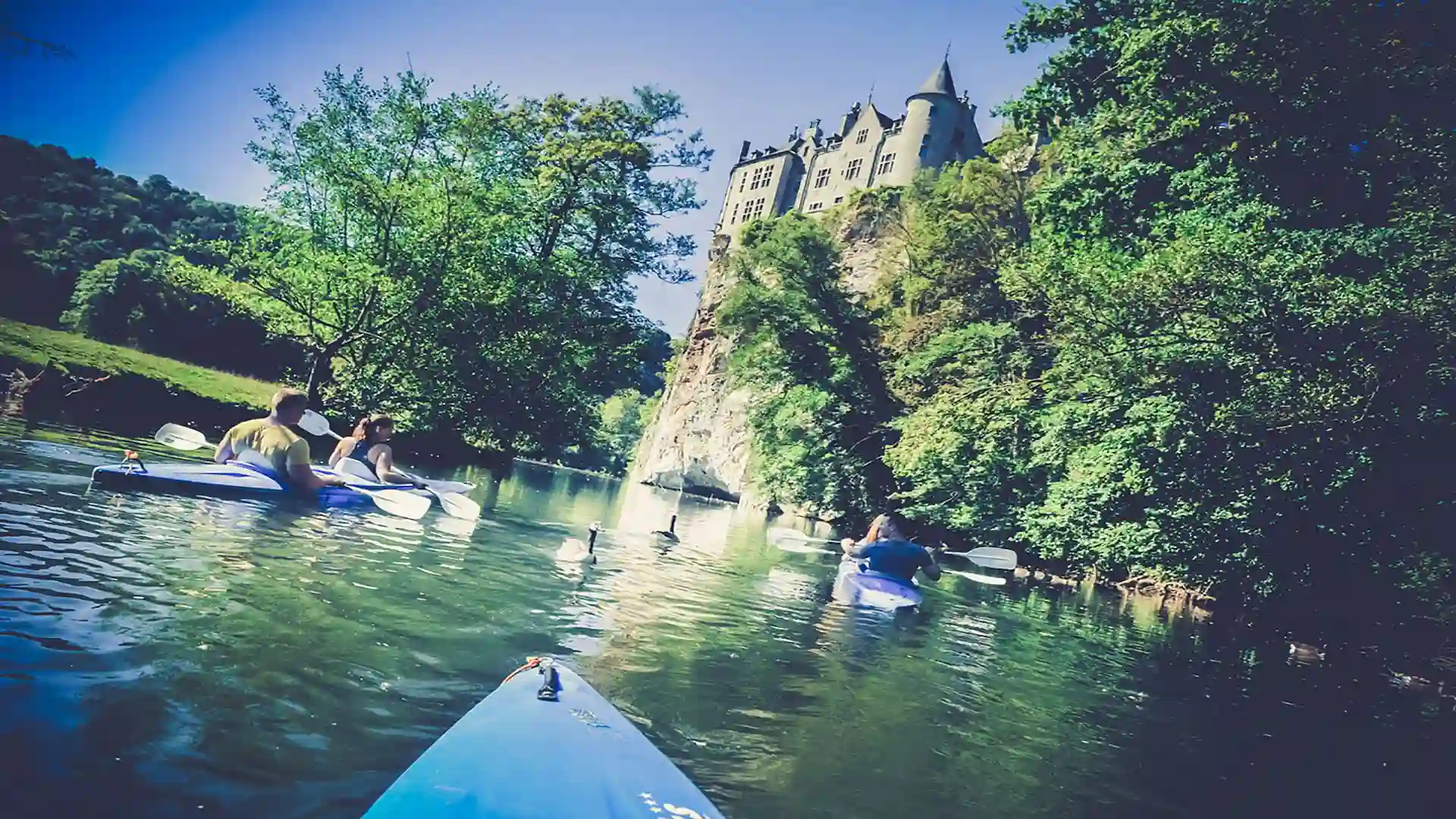
Can you kayak in the Semois Valley National Park?
Yes. The Semois is a class I river, navigable on many stretches through the heart of the National Park. Kayak Semois Ardenne offers 6 routes from 7 to 23 km from €17 all-in (shuttle, life jackets, dry bag included), with real-time flow monitoring and automatic email alert on navigation ban.
Ouvert tous les jours du 01/04 au 31/10. Fermé le 1er samedi de juin pour l'ouverture de la pêche.
Enter the information to see the rate…
Vos coordonnées
Finaliser la réservation
🔒 Paiement 100% sécurisé via Stripe. Pour valider votre réservation, nous demandons les frais de plateforme (10%). Le solde sera à régler sur place chez notre partenaire. L'adresse précise et le nom du prestataire vous seront communiqués par e-mail juste après.
« Une journée parfaite en famille sur la Semois. L'accueil d'Kayak Semois Ardenne est chaleureux, le matériel est impeccable (les kayaks sont modernes et propres), et le système de navettes gratuites est super bien organisé. Une adresse incontournable dans les Ardennes ! »
A
Annelies Peeters G
« Prachtige kajaktocht op de Semois vanaf Vresse! Zeer vriendelijk personeel en een uitstekende service met de pendelbus. De bijbehorende camping Au Petit Ben Gneur is ook een absolute aanrader voor natuurliefhebbers. »
P
Pierre-Yves Dubuisson G
« Superbe descente de 11km en kayak au départ de Alle-sur-Semois. La nature sauvage de l'Ardenne est magnifique sous le soleil du printemps. Tarifs très compétitifs par rapport à la concurrence. On reviendra ! »
S
Sandra Müller G
« Wunderschönes Erlebnis! Die Kajaktour auf der Semois war top organisiert. Das Team ist sehr hilfsbereit und spricht gut Deutsch. Die Landschaft der belgischen Ardennen ist einfach atemberaubend. »
D
Damien Claes G
« Excellent service de location de kayak et super camping au bord de la Semois. Les prix sont très corrects et l'ambiance est conviviale et familiale. Le petit bar-terrasse est parfait pour se désaltérer après l'effort. »
S
Sophie Mertens G
« Un accueil fantastique de dernière minute alors que nous n'avions pas réservé en plein mois d'août. Les gilets de sauvetage et les bidons étanches sont fournis gratuitement. Descentes très sécurisées, idéal avec les enfants ! »
T
Thomas Wright G
« Top-tier kayak rental on the Semois river. Extremely friendly staff, well-maintained kayaks, and reliable shuttle. The viewpoints along the river are absolutely stunning. Highly recommend this local business! »